Madari loop
If you're an avid hiker looking for an adventure in Cyprus, then the Madari loop trail is a must-visit. This challenging circular trail spans 13 km and is considered one of the best natural trails for hiking on the island. With an elevation gain/loss of around 600 meters and a peak of 1600 meters, this trail promises breathtaking views and stunning natural scenery.
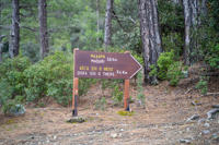
The trail starts at the Madari Fire lookout, which is the most popular starting point, but hikers can also start at Doksa si o Theos or Road Spilia to Madari junction. Regardless of where you start, you can be assured that you won't get lost as the trail is marked and is available on Google Maps.
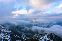
The Madari loop trail can be divided into two legs. The first leg starts at Doksa si o Theos and leads towards the Madari Fire Lookout. The route takes you uphill and provides spectacular panoramic views of both the south and north, with the village of Kyperounta and Chandria visible to the south and the coast of occupied Morfou and Mesaoria visible to the north.
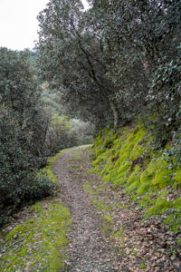
The second leg starts at the Madari Fire Lookout and leads towards Doksa si o Theos, taking a different route through a dense forest called "Adelfoi". This route is surrounded by greenery and offers a more magical experience, especially when you reach the Madari Fire Lookout and can enjoy a 360-degree view of the entire area.
While the trail is challenging and difficult, it's worth the effort as it offers stunning views and an opportunity to connect with nature. The Madari loop trail takes approximately 4 hours and 30 minutes to complete with an average speed of around 3 km/h. It's important to come prepared with suitable hiking gear, plenty of water, and snacks as there are no facilities or shops along the way.
The Madari loop trail is a popular hiking destination for locals and tourists alike, and it's easy to see why. With its stunning views, natural scenery, and challenging terrain, it's an experience that hikers will remember for a long time. As a final note, the name Doksa si o Theos means "Bless you God", a reflection of the trail's difficulty and the sense of accomplishment and gratitude that hikers feel upon completing it.
Trail Information
Distance
13.0 km
Difficulty
Hard
Trail Type
Circular
Duration
06:00h
Min Elevation
1039 m
Max Elevation
1581 m
General Information
Ratings
Spectacular
18
Fantastic
6
Enjoyable
1
Average
0
Terrible
0
4.7


