
Kakokefalos
If you are looking for a challenging hike with stunning views, then the Kakokefalos nature trail in Cyprus might just be the perfect choice for you. This trail is not for the faint of heart, as it is one of the most difficult hiking trails in the area, with a difficulty level of 3 (hard). However, the incredible views and lush vegetation make it worth the effort.
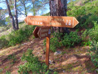
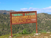
The trail begins at the starting point of the nature study trail Kakokefalos-Mantra of Kampiou, located one kilometer from the picnic area "Kionia" and 100 meters before the "Kakokefalos" peak, at an altitude of 1235 meters. The 5.5 km linear trail ends at the picnic area of Mantra Kampiou, passing through rough and rugged locations and over vertical cliffs. It is important to note that attempting to do the trail in reverse significantly increases the degree of difficulty, and should only be attempted by experienced athletes.
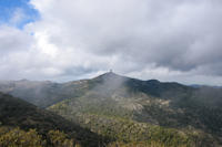
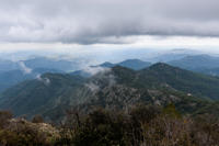
Despite the challenging terrain, the Kakokefalos nature trail offers panoramic views of the surrounding area and the plain of Mesaoria. Along the way, hikers will also encounter the ruins of an old forest station and many viewpoints from where you can see the villages of Larnaca and Nicosia.
It is essential to come prepared for this trail. Hikers should wear appropriate mountain shoes to avoid sliding, and bring enough water to stay hydrated. It is also recommended to be in good physical and mental condition before attempting this hike.
One of the most unique features of the trail is the changes in the volcanic rocks of the mountain, adding to the already impressive scenery. The sound of the nearby river will accompany hikers for a significant portion of the route, adding to the overall experience.
In conclusion, the Kakokefalos nature trail is not for the faint of heart, but those who manage to complete it will be rewarded with incredible views and a sense of achievement. Remember to come prepared and respect the difficulty level of this trail.
4 Photos
Trail Information
Distance
5.5 km
Difficulty
Hard
Trail Type
Linear
Duration
02:30h
Min Elevation
649 m
Max Elevation
1162 m
General Information
Ratings
Spectacular
0
Fantastic
1
Enjoyable
3
Average
0
Terrible
0
3.2